Back to prompt library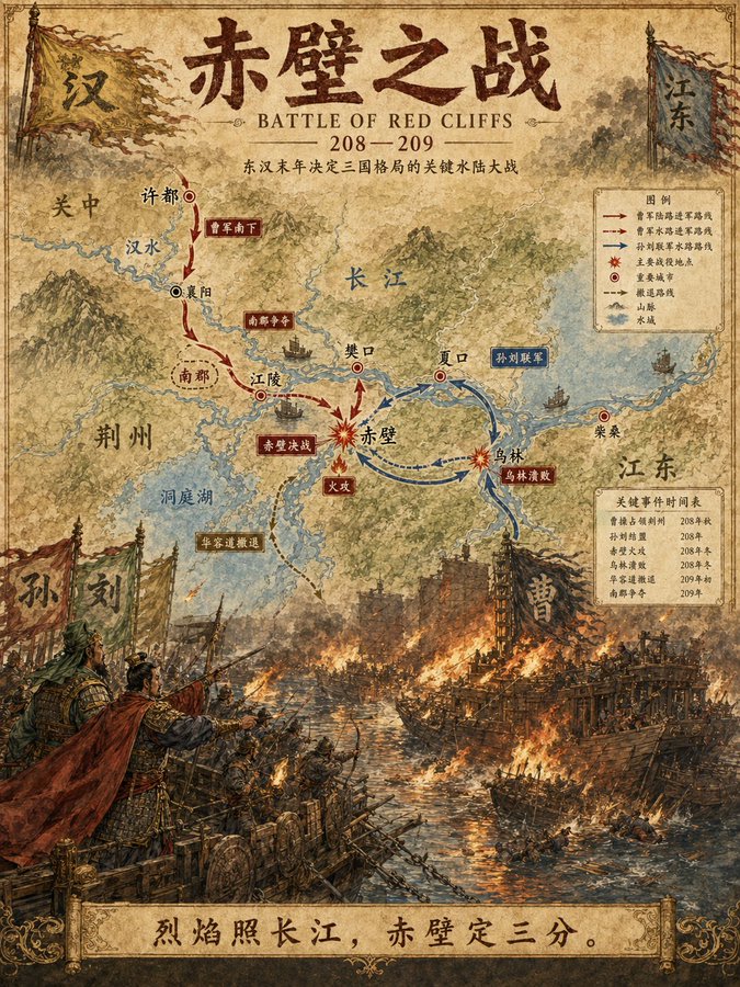


Prompt libraryImage Prompt
Watercolor Battle Map Explainer
Design a reusable image prompt for a watercolor battle map explainer, with editable terrain, troop arrows, front lines, legend, date markers, callouts, and delivery notes.
InfographicHistoryMap
Preview
Image Prompt
Recommended model
Flux 2 Flex
Output format
Image prompt template
Preview
Image Prompt
Preview for a watercolor battle map explainer, focused on route hierarchy, label editability, map legibility, and neutral historical constraints.
Full prompt
Watercolor Battle Map Explainer
Watercolor battle map prompt with editable terrain, movement arrows, front lines, legend, date labels, callouts, paper texture, delivery use, and historical accuracy checks.
Recommended model: Flux 2 FlexOutput format: Image prompt template
Full prompt
Image PromptDesign a production-ready image prompt centered on a watercolor battle map explainer. Define the historical scenario placeholder, region outline, terrain washes, rivers or roads, army movement arrows, front lines, control zones, numbered event markers, legend, date labels, caption boxes, scale cue, paper texture, watercolor palette, aspect ratio, and intended delivery use. Organize the map as a clear historical infographic with aligned label zones, readable route hierarchy, neutral annotation language, and enough margin for lesson slides, editorial explainers, museum panels, or social carousels. Keep all labels, dates, arrows, legends, and captions editable, leave room for source notes, and avoid distorted typography, fixed logos, real brand names, celebrity likenesses, protected characters, unsupported historical claims, partisan framing, cluttered routes, impossible geography, and elements unrelated to the watercolor battle map explainer.
Usage notes
Replace the battle scenario, region outline, route arrows, faction labels, date markers, legend items, source-note area, palette, aspect ratio, and final delivery use before running.
Prompt FAQ
Before you use this prompt
Quick checks for inputs, model fit, and how to adapt the template without weakening the result.
What should I customize in this watercolor battle map explainer?
Replace the battle scenario, region outline, route arrows, faction labels, date markers, legend items, source-note area, palette, aspect ratio, and final delivery use.
How should I review the image output?
Check route readability, label editability, geographic plausibility, neutral wording, source-note space, and whether any unsupported claims or distorted typography appeared.
Can I adapt this for another history topic?
Yes. Keep the map structure and review checks, then swap the region, timeline, movement paths, legend, callouts, and delivery format for the topic you are explaining.
More prompts in this mode